This post is also available in: Croatian
[nivo effect=”fade” directionNav=”button” controlNav=”true” width=”720px” height=”360px”]
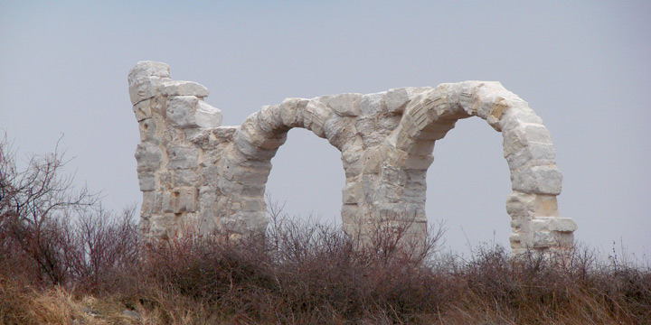
[image caption=”Burnum”]http://hotspots.net.hr/wp-content/uploads/2012/03/burnum.jpg[/image]
[image caption=”Arheoloski Muzej Split”]http://hotspots.net.hr/wp-content/uploads/2012/03/arheoloski-muzej-split.jpg[/image]
[image caption=”Nadgrobna stela sa područja Burnuma”]http://hotspots.net.hr/wp-content/uploads/2012/03/Nadgrobna-stela-sa-podrucja-burnuma.jpg[/image]
[image caption=”Rimske legije”]http://hotspots.net.hr/wp-content/uploads/2012/03/rimske-legije.jpg[/image]
[image caption=”Trasa rimske ceste istočno od utvrde Čačvina”]http://hotspots.net.hr/wp-content/uploads/2012/04/Trasa-rimske-ceste-istocno-od-utvrde-Cacvina.jpg[/image]
[image caption=”Tilirium”]http://hotspots.net.hr/wp-content/uploads/2012/04/Tilirium_1.jpg[/image]
[image caption=”Tilirium”]http://hotspots.net.hr/wp-content/uploads/2012/04/Tilirium_2.jpg[/image]
[image caption=”Tilirium”]http://hotspots.net.hr/wp-content/uploads/2012/04/Tilirium_4.jpg[/image]
[image caption=”Tilirium”]http://hotspots.net.hr/wp-content/uploads/2012/04/Tilirium_3.jpg[/image]
[image caption=”Muzej, postav logora Burnum”]http://hotspots.net.hr/wp-content/uploads/2012/04/Muzej-postav-logora-Burnum.jpg[/image]
[/nivo]
Augustus’, and then Tiberius’ man of trust, legatus Augusti pro praetore Publius Cornelius Dolabella, is undoubtedly a name that captures particular attention in the chapter on Roman Dalmatia. An authority figure among the legions, and a skilled administrator of the Empire (14 BC – 20 BC), launches capital infrastructure projects with a foothold in the construction of a road network in the east Adriatic areal. Following the road sections from the reign of the Emperor Augustus, Dolabella begins the construction of five new roads to connect newly pacified Illyrian areas with the Adriatic littoral as quickly and efficiently as possible.
In less than seven years of Dolabella’s administration, more than 550 miles (millia passus) of roads have been built, at a very difficult and inaccessible terrain. The so-called inscriptions of Solin, epigraphic monuments preserved in 4 plates that were embedded in the steeple of the cathedral of Split, accurately testify to this venture. They were probably transferred as a building material from the territory of the ancient city of Salona, destroyed during the Avar – Slavic invasion in the 7th century. Exhibited in the Lapidarium of the Archaeological Museum of Split, they are an important source for the study of the first Roman communication network, and of the topography of the former province of Dalmatia.
In addition to the names of the roads established during Dolabella’s mandate on the orders of Tiberius Caesar, the son of the Divine Augustus, the inscriptions of Solin also state constructors for some of the routes. Thus in tracing a road a colonia Salonitana ad fines provinciae Illyrici, actively participate vexillations of the legion VII and XI (divisions of soldiers separated from the major legions for special operational tasks), while the members of the legion VII raise via Gabiniana ab Salonis Andetrium. Although the constructors of the remaining communications (a Salonis ad Hedum castellum Daesitiatium, ad Bathinum flumen, ad imum montem Ditionum Ulcirum) are not explicitly stated, it is possible that in tracing these roads the already mentioned troops have made their contribution. The maintenance and upbuilding of the roads were typically conducted by a central office responsible for their construction (cura viarum).
Dolabella’s road network towards the inland shows that their starting point was Salon, the administrative center of Roman Dalmatia. All of the roads led to the hinterland through the gulch of Klis and then branched in three directions. One of the routes led to the camp of the auxiliary Andetrium troops (Gornji Muć), and the other to the Aequum (Čitluk near Sinj), an agrarian colony of the Roman veterans of the legions VII and XI founded during the rule of the Emperor Claudius, probably after the 42 AD. A third in a series of directions led to the beneficiary station Pons Tiluri (Trilj) on the river Cetina (Hyppus). The roads from here branch off to the northeast towards the mining district Argentaria (the area around the town of Srebrenica in eastern Bosnia and Herzegovina), and to the southeast via trading colony Narona (Vid, near Metković) to the cities Scodra (Skadar) and Dyrrachion (Drač), Albania. The significance of this transportation hub in the late Roman period is suggested by the data from the grant of the Byzantine Emperor Justinian I the Great, which among other properties gives the Benedictine monastery at Monte Cassino, Ponte Ciluri in Dalmatia. Dolabella’s roads initially had characteristics of a military nature (viae militares), and over time they started to assume the public role (viae publicae).
The military content was primarily reflected in many small fortresses (burgi, castella), watch towers (speculae) deployed along some routes and networked with the legion castrums (castra stativa). In the region of Dalmatia two complexes with such purposes have been found – the military camp Burnum, located north of Kistanje in the village Ivoševci; and Tilurium, built on the location of the present settlement Gardun near Trilj. The whole defense system was designed to stabilize peace in the region, and to support the Roman authorities after breaking the resistance of the Pannonian – Delmatae alliance in the Batonian rebellion (9 AD). The Romanization of domicile populations fits in this course – Dalmatia was not an exception in relation to other areas subject to the Empire.
The presence of the army in the province guaranteed the safety of the roads from frequent robbers raids (latrones, grassatores), that long after the Roman occupation remained a threat to normal transport and trade routes. Even in peacetime, the travels took place mostly at daytime, to welcome the night in the specified objects – road branches (mansiones) and taverns (tabernae). The departments of the traffic supervisors (stationarii) were responsible for compliance with traffic laws and the traffic safety in general.
All of the major Roman road directions, that at the time had equal relevance to the modern highways, are marked by stone pillars – milestones (marmor milliarium) with up to 40 cm in diameter and 1.50 m in height. The name of today’s settlement Dicmo was created from the station code on the 10th milestone from Salona (ad decimum milliarium). Milestones are the most authentic evidence of the existence of some Roman road, especially if they were found in situ. They were raised as honorary monuments of emperors (for example, the milestone from Velić near Trilj, built in the honor of the emperor Maximinus the Thracian). It remains unknown whether Dolabella’s roads had milestones, but they might have been set only when the roads assumed increasing importance for the civilian traffic in general.
Text: Lino Ursić
Photo: source Lino Ursić, TZ grada Trilja
This post is also available in: Croatian


